Before appropriate measures can be taken to curb relevant air emissions an accurate assessment of the current situation is required. VITO offers different air quality assessment and planning tools to model high resolution air quality maps down to street level.
Our experts provide policymakers with the scientific evidence required to make the best choices to improve air quality. This evidence is based on a detailed analysis of the current situation and future policy scenarios.
VITO offers the ATMO-Street model to derive high-resolution air quality maps down to the street level for air quality assessments and planning.
This model chain is integrated into a user-friendly ATMO-Plan tool harmonising air quality modelling for planning and environmental impact assessments.
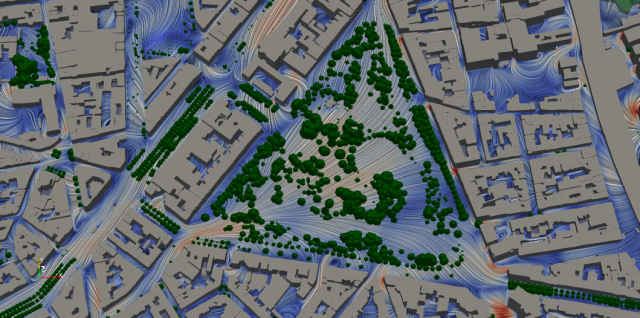
NO2 level in Brussels with ATMO-Street

Key applications
Development of IT tools to support air quality policy
Design and development of tailor made software tools to support policy makers in the analysis and planning process.
A NO2 source apportionment tool for road transport emissions
Air quality plans and clean air strategies
Low emission zones and sustainable transport management
Residential heating mitigation: support solid fuel strategies
Regional and local scale environmental impact assessments
Assessments for compliance, spatial representativeness and source apportionment
Impact of nitrogen deposition on Natura 2000 sites
Capacity building and customized model competency training
Data assimilation to refine air quality maps with sensor network information
Smart city applications and digital twins
Air quality models can be coupled to Local Digital Twins to integrate air quality modelling and maps into cross-domain decision support tools
Prototype digital twin city of Bruges offers opportunities for all of Flanders